Showing posts with label Aboriginal. Show all posts

Friday, May 27, 2016

Djiru Warrangburra Peoples share their traditional knowledge across generations: a P3DM experience in Australia

Attracting approximately 2 million tourists each year, the Wet Tropics region is home to more than 18 distinct Rainforest Aboriginal tribal groups for whom the region holds deep cultural and spiritual significance. Many of these Aboriginal groups deal with multiple threats to their traditional landscapes, due to pressures such as tourism, agriculture and population growth. As some of the most disadvantaged people in Australia, Aboriginal people often do not have the resources to address these threats comprehensively and regularly experience the loss of vital cultural heritage and access to their traditional landscapes as a result of these pressures.

The Djiru Warrangburra people are one of the culturally rich Rainforest Aboriginal tribal groups of the region. They live in and around the rainforests and coastal flats of the Mission Beach area, about 2 hours south of the regional centre of Cairns.

Djiru traditional lands are also home to some of the last remaining numbers of the southern cassowaryCasuarius casuarius johnsonii - a species endemic to the Wet Tropics World Heritage Area and listed as endangered. 

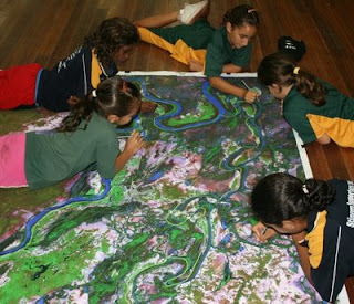
In April 2016 Djiru people began implementing a participatory 3-dimensional model (P3DM) covering close to 60,000 hectares (576 sq km) of land and sea, and including areas such as World Heritage, National Parks, freehold tenure.

At a scale of 1:10,000 the Djiru P3DM exercise is intended to encourage intragenerational sharing of knowledge vital to the longevity of Djiru culture ad the identity of Djiru people. Still in progress the P3DM is expected to be complete by June 2016. The project is being facilitated by the Wet Tropics Management Authority and is funded under the Queensland Gambling Community Benefit Fund.

Thursday, January 21, 2016

Hands on Culture - Participatory 3D Modelling with Mandingalbay Yidinji People in Australia


This video is about the 3D mapping project of the Mandingalbay people near Yarrabah North Queensland. This project was supported by the Wet Tropics Management Authority, IUCN and CTA to producing a short film based on the amazing project the community took on to bring their 3D mapping project to life.

Wednesday, November 05, 2014

Mandingalbay Yidinji Traditional Owners mapped their lands in 3 dimensions - Don't miss their feedback at the World Park Congress in Sydney

Australian aboriginal Mandingalbay Yidinjii people have recently completed a P3DM exercise within the ancestral territories (traditional country) in Queensland.

They will showcase their work and replicate the population of one section of their 3D model during the World Parks Congress in Sydney They will do this at the WIN and Pacific Community Dialogue Pavilion (Pavilion 2) on 13-15 November. You should pass by and talk to them about their exciting experience.

On Monday, 17 November 8:30 – 12:00 they will officially present their achievements at the WIN & Pacific Community Dialogue Pavilion (Pavilion 2) during the session “Voices and choices: The risks and values of georeferencing traditional and local knowledge”. This session is organised by CTA with support provided by IUCN, UNDP, GEF-SGP and the WTMA.

More on this activity and related events at the Worls Parks Congress is found on this flyer.

Wednesday, October 22, 2014

Forthcoming P3DM-related activities at the 6th World Park Congress, Sydney 12-19 November 2014

Click to download the flyer
This is to update you about a series of events which will focus on Participatory GIS practice during the forthcoming IUCN World Park Congress. The events we are organising have a common denominator: Participatory 3D modelling (P3DM).

Below is a short description of the 3 events / activities:

Rolling activity (13-17 November),  at the WIN & Pacific Community Dialogue Pavilion (Pavilion #2)

Title: Participatory 3D modelling of the traditional country of the Mandingalbay Yidinji People, Queensland, Australia

Organisers: Wet Tropics Management Authority with support provided by IUCN, CTA and UNDP Equator Initiative with financial support provided by UNDP GEF-SGP

Starting on 13 November and for the duration of the conference, representatives from the aboriginal Mandingalbay Yidinji People will work on a 3D Model reproducing their ancestral territory within the Wet Tropics World Heritage site. The model will be at a 1:10,000 scale and include terrestrial and coastal components. It will be a replica of a larger model completed by a wider representation of the community in Queensland with support provided by the Wet Tropics Management Authority, IUCN and UNDP GEF-SGP. The population of the 3D model with data will occur during the conference within the WIN Communities Dialogue Pavilion. Support in the process will be offered by Partners with Melanesians. The completed model will be presented by Mandingalbay Yidinji People during the Side event “: The risks and values of geo-referencing traditional and local knowledge” which will take in the same pavilion on Monday 17 (see below).


Pavilion event; 17 November 8:30 – 12:00, WIN & Pacific Community Dialogue Pavilion (Pavilion #2)

Title: Voices and Choices: The risks and values of geo-referencing traditional and local knowledge

Organisers: CTA and IUCN

Note: Coffee, tea and cakes will be served to participants by mid-morning
This event focuses on Participatory 3 Dimensional Modelling (P3DM) a method within the Participatory GIS family which enables communities to geo-reference and spatially document their complex systems of traditional land/seascape knowledge. The method benefits from its integration with GIS, multimedia production, Web2.0 and social media and serves multiple purposes, including landscape planning, rights advocacy, inter-generational knowledge transmission, influencing policy-making and enhancing communities’ socio-environmental resilience.

At the onset of Participatory GIS (PGIS) practice, concerns were expressed that the nature of and access to GIS would simultaneously marginalize or empower different groups in society. The practice evolved along different lines and among diverse interest groups. Currently it embraces a blend of applications ranging from Internet-based spatial multimedia to field-based participatory methods with a modest GIS component. In this fast-evolving context, there is a seemingly unstoppable excitement about georeferencing human physical, biological and socio-cultural worlds and making the information publicly available. This embodies both potentials and risks, aspects which need to be taken into consideration by knowledge holders, technology intermediaries/facilitators and researchers.

A physical 1:10,000 scale 3D model completed by the Mandingalbay Yidinji People representing a portion of their ancestral territory within the Wet Tropics World Heritage site in Queensland, Australia will be showcased at the event. Representatives from the community will share their experience in going through the various phases of the process, how they dealt with sensitive data, and their plans on how best to make use of acquired skills, knowledge and completed products (the model and derived maps) in their future endeavours.

Coordinator: Giacomo Rambaldi (rambaldi[at]cta.int)

Session within Stream 7; Tuesday 18 November 2014, 8:30 AM - 10:00 AM

Title: Knowledge management and technologies: Participatory 3D modelling in Protected Areas, landscapes and seascapes

Organisers: IPACC and CTA, in cooperation with Association des Femmes Peules Autochtones du Tchad, Minorités Pygmées du Gabon, and Yiaku People’s Association of Kenya, Melca Ethiopia and other indigenous peoples and local communities.

Background and summary: IPACC, African Biodiversity Network and other organisations have used Participatory 3 Dimensional Modelling (P3DM) to represent complex systems of indigenous landscape knowledge to themselves and decision-makers. P3DM, a geo-referenced and yet participatory system of knowledge representation serves multiple usages, including landscape planning, rights advocacy, inter-generational knowledge transmission and improving conservation.

The Technical Centre for Agricultural and Rural Cooperation (CTA) promotes skills transfer in P3DM for indigenous peoples and local communities in Africa, Caribbean and the Pacific regions.
Oral knowledge of biological systems emerges through the methodology, associated with resource governance, rights and indigenous values. The tool provides a multi-use medium for negotiating land use, understanding customary use systems, education for sustainability, and empowering indigenous peoples as holders of expert knowledge in conservation and planning.
P3DM case studies describe a broad range of ecosystems and contexts. P3DM provides a valuable tool for intercultural understanding of diverse knowledge and land use systems relevant for Protected Areas.

Coordinators: Nigel Crawhall (nigel.tilcepa[at]gmail.com) and Giacomo Rambaldi (rambaldi[at]cta.int)


Monday, September 05, 2011

The Manus MOSAIC - Participatory 3D modeling for climate change adaptation across Manus Province, Papua New Guinea

At the Manus Province Climate Change Seminar ‘Manus Way Forward’, October 2010, over 70 participants presented and shared experiences, expertise and ideas on how to adapt to climate change impacts. As part of the recommendations, representatives from the Provincial Government suggested using Participatory 3D modeling (P3DM) as a tool to help convene stakeholders and discuss province-wide responses to climate change impacts that would support and build on local efforts and scale-up impacts and opportunities.

In particular, the tool was proposed as a way to initiate discussion on a protected area network for Manus, the Manus ‘MOSAIC’. The exercise would be an initial step in outlining the spatial coverage of key ecosystem services, such as watersheds, reefs and mangroves, and representing and discussing opportunities for strengthened management of these areas under a future of climate change, and in the context of social and economic development for the province. The opportunity to involve local stakeholders from all LLG jurisdictions in this process will help develop a roadmap for the development of a Manus ‘MOSAIC’ protected area network.

Participatory 3D modelling

Participatory 3D modelling (P3DM) is a fully collaborative exercise that combines community mapping with open discussions on land-use and land-use planning scenarios.  It combines geographic precision with local, individual spatial knowledge and ‘mind-maps’ of locality and familiar settings.  During a P3DM exercise, all participants contribute to make a physical, hands-on wood-and paper model, to scale, of their community, island or area. This is typically made on a large table in the centre of a meeting hall, school or other public place. Once the model is made, then people become ‘resource persons’ and informants, and everyone will contribute to placing features and places onto the model. Key informants, such as elders and experienced fishermen or foresters, will offer their view of past events, of boundaries, of key localities and times for certain activities, and these can be discussed, and learned, by all participants.

Below is the video produced during the Solomon Islands event in February 2011.


In this way, the model is more than just a map, it is a representation of spatial knowledge of the participants, and a source of discussion and interpretation around key issues.

Proposed area of Manus to be represented by the P3DM exercise (Map by Nate Peterson, TNC)
Although one key objective of this exercise is to plan for protection and restoration of key natural features, and to plan for possible climatic changes, other issues that are important to the province and the participating communities can be discussed in the same context. Furthermore, the model and the information can be used again, and again, for collaborative discussions and planning on key development issues. Digital GIS can be extracted from the model, and vice-versa, to aid and inform future discussions.  In this way, scientific information can be easily communicated and integrated with local knowledge and understanding.

Activity overview

The P3DM exercise will take place over a two-week period, from Monday 29th August to Friday 9th September. The first week will be dedicated to constructing the blank relief model, working closely with the local high-schools schools in Lorengau to allow students the opportunity to have a hands-on lesson in geography. It will also allow those participants interested in training / learning how to carry out a P3DM the opportunity to get involved.

The second week will concentrate on making the blank model come alive. Participants from all areas of Manus, and with all technical and local backgrounds, will discuss and add information to the model, including point data (features such as houses, schools, waterfalls, caves etc), line data (roads, streams, rivers, tracks, paths, boundaries, fences, cables, runways etc) and area data (polygons, such as mangroves, forest concession areas, reef flats, beaches, airports etc). Local knowledge on boundaries and features from participants from each part of Manus will contribute to an overall local picture of the province. Official and technical data can also be cross-referenced with local understanding, and represented on the model.

Towards the end of the second week, a facilitated discussion will focus on key issues, including ecosystem services and existing and proposed protected areas; current and proposed development activities (mining, forest concessions, urban and commercial expansion); and information related to predicted climate change impacts.

Future discussions on the proposed Manus MOSAIC protected area network can build on this initial analysis and use the 3D model for further participatory mapping.

General objectives of the Manus MOSAIC P3DM:

The P3DM exercise will enable all participants:
  • To learn and understand Geographic Information Systems (GIS) in an open, hands-on and accessible way
  • To participate in spatial planning for their own area as well as for the whole province
  • To identify planned developments and trends in land-use change, and assessing the impacts of these changes on key ecosystem services
  • To open a discussion on climate change impacts and how to integrate adaptation into spatial planning at local and provincial scales
  • To discuss management and protection measures for key ecosystem services in the context of scaling-up beyond local efforts to ensure the best network of connectivity in conservation and adaptation efforts for the whole province
Author: James Hardcastle, The Nature Conservancy
Source: Eldis Communities | blog

Monday, May 23, 2011

Participatory 3D Modelling for developing climate change adaptation plans in Boe Boe, Solomon Islands

I’d like to thank all the team who made the ten-day ‘Participatory 3D modelling (P3DM) for climate change’ engagement with Boe Boe community, Solomon Islands, such a successful event.
It is the first time that such innovative, yet simple, mapping and communication tools have been used in the context of climate change adaptation.
The team, led by Kenn Mondiai of Partners With Melanesians, and the Solomon Islands’ TNC staff and local partners, were able to hand over a vibrant, illustrated, ‘living’ and accurately-scaled model of the community customary lands and waters, at a ceremony involving Boe Boe village and neighboring communities.
The model took teams of students and volunteers 3 days to build, and then community members added the detail – from their own houses, their gardens, their route through the mangroves, forest paths, conservation areas, and anything else they reckoned important to note.
At the same time, climate vulnerability and adaptive capacity surveys with households, led by Esther Ririmae and Gideon Solo, and follow-up work by the team with community members on a range of key issues, allowed the modeling exercise to focus on community perspectives of climate change impacts, and the villagers’ collective ability to respond to these and other development pressures.
Of real interest, digital and ‘scientific’ modeling provided by TNC GIS folks (Nate Peterson, Seno Mauli) and Javier Leon of University of Wollongong, was seamlessly integrated into the mapping exercise and gave the community additional perspectives on their local knowledge, to aid decision-making.
The exercise has given all those involved, and all the partners in the Australian Government / AusAID supported project ‘Building the Resilience of Communities and their Ecosystems to the Impacts of Climate Change’, a chance to explore how local communities can assess potential climate impacts, be aware of their own capacities and vulnerabilities, and make decisions going forward.
Please find the attached initial write-up of the activity in the 'files' section at this link http://community.eld...  , along with some resources on conducting P3DM. More detailed reports will follow from Partners With Melanesians and other papers on the lessons learned from the exercise.
The guru of P3DM, Giacomo Rambaldi, based at the Technical Centre for Agricultural and Rural Co-operation (CTA) in the Netherlands, has worked with both Kenn and myself before on the tool, and has an online resource kit available at http://pgis-tk-en.cta.int
Next up is 3D modeling at the provincial scale in Manus!

The initiative has been implemented in the framework of the Australian Government / AusAID-funded project ‘Building the Resilience of Communities and their Ecosystems to the Impacts of Climate Change in the Pacific”.

Friday, January 08, 2010

Interview with Steve deRoy about the role of networking and communication in PGIS practice


In this interview, Mr. Steven DeRoy illustrates the power of networking and the importance of integrating this practice into the daily realm of PGIS. These professional exchanges create an opportunity to dialogue with likeminding professionals, allowing practitioners to share ideas and approaches to solve common challenges. Maps also play a vital role in communicating ideas amongst different parties and for advocating change in current affairs

Thursday, June 11, 2009

Sculpture and Science help in Planning to Preserve The Mutton Hole Wetlands in Australia

A 3D model of the Mutton Hole Wetlands near Normanton has been developed as a starting point for community consultation and discussion about how best to preserve and use the Mutton Hole Wetlands.

The Mutton Hole Wetlands are situated just to the North and West of Normanton, and are a part of the Southern Gulf Aggregation, the largest continuous wetland of its type in northern Australia. Being vital for bird migration routes across northern Australia, the Southern Gulf Aggregation is considered to be of state, national and international significance.

In the past the wetlands formed part of the neighbouring Mutton Hole cattle station, but the area was declared a Conservation Park in 2004. Currently managed by Queensland Parks and Wildlife, Carpentaria Shire Council has been considering managing the park themselves. As a part of this consideration the Northern Gulf Resource Management Group has gained funding to write a management plan for the wetland.

The management plan will highlight Aboriginal culture as well as the environmental values of the wetland in a plan to conserve it for future generations. There is strong support from the scientific and local community for use of the wetlands for bird watching, teaching and eco-tourism. As a step towards greater community consultation a model of the wetland area was built and is now located in the Normanton Visitor Information Centre (Burns Philp Building).

Over six weeks in April and May 2009 students and staff from Normanton State School and the Gulf Christian College worked together with Dr Isla Grundy of CSIRO to construct a 3D model of the Mutton Hole Wetlands, using a technique called Participatory 3D Modelling (P3DM).

The model was made by first tracing the image of the wetlands from a 1:9500 satellite image onto a large piece of cardboard, then other features were added on or cut out. Finally, the rest of the landscape was painted onto the cardboard and the boundary of the Conservation Park marked with thread.

P3DM is a relatively new technique developed in the Philippines to support collaborative resource use and management, aimed to facilitate community participation in problem analysis and decision-making. This is the first time this participatory technique has been used to make a landscape model from cardboard in Australia.

Since mid-May 2009 the model has been displayed at the Normanton Visitors Information Centre and on Thursday 21st May there was a formal public opening when students, parents and interested community members came to see what the schools had been working on. The exhibition was opened by Vicki Jones of Northern Gulf, along with Isla Grundy of CSIRO and Agnes Hughes from Normanton State School. The forty or so people who attended were able to take a closer look at the model and discuss wetland history and potential use. The community at large was invited to give it’s opinions and ideas on how the Mutton Hole Wetlands should be managed and used in the future through individual community consultations and group discussions held at the Information Centre.


Source:
Dr Isla Grundy
Community Agro-Ecologist CSIRO Sustainable Ecosystems,
JCU / CSIRO Tropical Landscapes Joint Venture
Australian Tropical Forest Institute, James Cook University, Cairns, QLD 4870