Showing posts with label geocoding. Show all posts

Friday, March 29, 2013

Oil palm expansion in the Philippines: geo-tagged evidences of an imminent tragedy

By ALDAW Network (Ancestral Land/Domain Watch): Between June and August 2009, an ALDAW mission travelled to the Municipalities of Brooke’s Point and Sofronio EspaƱola (Province of Palawan) to carry out field reconnaissance and audio-visual documentation on the social and ecological impact of oil palm (Elaeis guineensis) plantations.  The mission’s primary task focused on two major objectives: 1) gathering data through interviews, ocular inspection and participatory geographic information systems methodologies; 2) providing communities with detailed information on the ecological and social impact of oil palm plantations, to allow them to make informed decisions while confronting oil palm companies, state laws and bureaucracy.

Successive ALDAW field appraisals in oil palm impacted areas took place between July 2010 and early 2013, and included the Municipalities of Aborlan, Rizal and Quezon. During ALDAW field research, GPS coordinates were obtained through the use of a professional device connected to the camera’s hot shoe.  

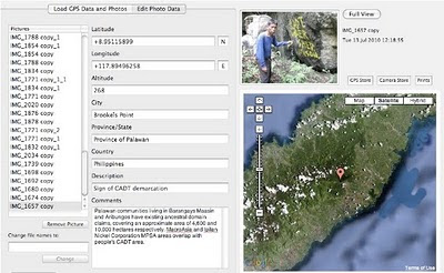
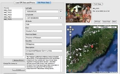
The geotagged images have been loaded into a geo-aware application and displayed on satellite Google map. The actual ‘matching’ of GPS data to photographs has revealed that, in specific locations, oil palm plantations are expanding at the expenses of primary and secondary forest and are competing with pre-existing cultivations (coconut groves, fruit tress, wet-rice, etc).

The conversion of productive paddy land and forest into oil palm plantations is particularly evident in the Municipality of Quezon .

Oil palm plantations have also expanded in areas used by indigenous people for the cultivation of local varieties of upland rice, root crops and fruit trees.  Furthermore, the fencing of large areas of oil palm plantations makes it difficult for local communities to reach their upland fields and forest.

Geottaged evidences have also revealed the exact location of commonly used NTFPs, such as buri palms (Corypa elata) and bamboos that are being destroyed through massive land clearing by oil palm companies.

Moreover, geocoded photos have provided indications on the location of rivers and freshwater sources that are being incorporated into oil palm plantations and that are likely to become polluted through the use of pesticides and fertilizers.

These freshwater sources provide potable water for local communities and some of them are essential for the maintenance of community-based dams.

Initial steps are now being taken to establish collaborative exchanges between the oil palm impacted indigenous communities of Palawan and those of Mindanao which are facing a similar fate.  These exchanges and cross-visits will include training courses on geotagging and participatory videos done by indigenous peoples (ALDAW staff) to other indigenous groups such as the Higaonon of Bukidnon.  In addition to this, during such cross-visits, common advocacy strategies to resist oil palm expansion nationwide will be identified.

In response to recent research findings, see Palawan Oil Palm Geotagged Report 2013 (Part 1 and Part 2)

ALDAW has launched two major campaign initiatives:
  • Petition 1 (covers Palawan and Mindanao, addressed to the National Government) 
  • Petition 2 (covers Palawan specifically, addressed towards the Provincial Government, the Palawan Council for Sustainable Development (PCSD) and the National Commission on Indigenous Peoples (NCIP)
Oil palm expansion on indigenous land both in Palawan and Mindanao should be stopped with haste, before its adverse socio-ecological impact becomes irreversible. Please, give your contribution by signing the above petitions.

Wednesday, August 01, 2012

Palawan - our struggle for nature and culture


The struggle to save Palawan (known as the Philippines’ Last Frontier) is not only about saving trees and rare species. It is also about nourishing the Filipino cultural heritage, so powerfully represented by those indigenous communities that - after escaping Spanish and American colonization (while resisting the new ‘mining imperialism’ now) - continue to represent the 'living roots' from which all Filipinos originate. Therefore, environmental plundering by mining companies is not only a crime against nature but it is also a crime against culture, a sort of genocide that annihilates the most profound roots of the Filipino's history and ultimately plunders the cultural heritage of the whole nation! In this movie, Kawali, the mythical ancestor depicted by Batak narrators emphasises humility and trust towards the supernal beings in charge of animals and plants. On the contrary, the attitude of Kawali’s brother-in-law comes to represent the epitome of inappropriate behaviour, such as the lack of respect towards the mystical keepers of animals and - here specifically - towards the “father of bees”: a relationship that contemporary Batak continues to restore though the lambay ceremony. The sudden switch between the narration of the Batak myth and the threats posed by mining companies serves to introduce the work of ALDAW, a local network of indigenous peoples struggling for the protection of their ancestral land against large-scale corporations.

Tuesday, July 27, 2010

Palawan ‘UNESCO Man and Biosphere Reserve’ in the grip of Mining Companies?

Puerto Princesa - ALDAW. On the 7th of June (see IC release) 600 protesters from farmers and indigenous communities reached the capital city of Puerto Princesa on Palawan Island requesting the Provincial Government not to endorse the proposed mining plans of MacroAsia and Ipilan Nickel Corporation (INC). As a result of the negotiations taking place between the protesters’ delegation and policy makers in Puerto Princesa, the Provincial Government agreed that endorsement of both MacroAsia and INC should have required further investigation. However, that promise was not honoured and, after a few days, the Provincial Government gave his endorsement to MAC and INC to operate in one of the best conserved biocultural paradises found in the Philippines, and in South-East Asia as a whole.

The area given out to mining concession is also inhabited by traditional indigenous Palawan having limited contacts with the outside world. Moreover, the Gantong range and neighboring areas where MAC and INC intend to operate are within the area recently declared as Mount Mantalingahan Protected Landscape, pursuant to Presidential Proclamation no. 1815.

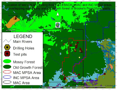
Location of test pits and drilling holes within the mining concessions and
their overlap with mossy and old growth forest in Brook's Point Municipality
Both the MPSA areas of MacroAsia and INC are located in ecologically valuable areas which include watersheds, hunting/ agricultural grounds, extractive reserves of Non-Timber Forest Products (NTFPs) such as Almaciga (Agathis philippinensis) resin, on which upland indigenous communities depend for their daily subsistence. Also indigenous peoples’ sacred and worship sites are found within the mining tenements of these companies.

Representatives of ELAC (Environmental Legal Assistance Center) are now filing cases against government officials and their respective agencies for having endorsed MAC and INC without securing first the needed social acceptability requirements and in disregard of the Strategic Environmental Plan (Republic Act 7611).

Say ELAC Atty. Edward G. Lorenzo: “the sustainable management of the entire Province is, in fact, governed by the SEP law which prohibits any human activity in those areas that are classified as ‘core zones’ and that – very unfortunately - are now part of MAC and INC mining tenements”. A indigenous member of the indigenous community of Gieb (Barangay Maasin, Brooke’s Point Municipality) also claims: “they (mining personnel of MAC) just entered our land without asking permission, and they removed our rice plants to excavate big ditches in our agricultural fields and also up into the mountains, only few meters away from the Balgtik (Agathis Philippinensis) trees that we sell and from which we depend for our survival”. According to another member of the same community: “MacroAsia peoples have removed soil and trees also in those sacred forest that we call lylien and that are inhabited by powerful super-human beings (Taw Kawasa)”.

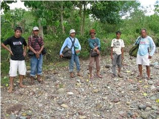
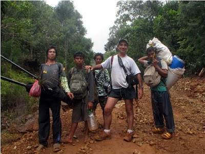
Between 12-16 July a geotagging field reconnaissance carried out by the ALDAW (Ancestral/Land Domain Watch) in collaboration with the Centre for Biocultural Diversity (CBCD) of the University of Kent has confirmed that MacroAsia test pits and drilling holes are found in ‘core zones’ (areas of maximum protection) around and even above 1,000 m ASL. Indigenous peoples trained on basic GPS and Geotagging technologies, with their own set of equipment divided into two groups to cover a large portion of the MAC and INC mining tenement area.

It appears that both MAC and INC have violated the basic tenets of the Strategic Environmental Plan (SEC) and also of the Indigenous Peoples Rights Act (IPRA Law), a national law protecting the interests of Indigenous Cultural Communities (ICC). Faced by this and similar accusations, the Provincial Government recently made a statement according to which MacroAsia and INC may not be allowed to operate in core zones, but their activities might be limited only to multiple/manipulative use areas. Again, ocular inspection and GPS data obtained by ALDAW and CBCD indicate the those portions of MacroAsia and INC mining concessions, which are outside the core zones, still include forested buffer zones which, obviously, do not fit by any means into the standard definition of ‘multiple/manipulative use zones’, where – according to the law – mining might be allowed. In fact, the mining claims of both MAC and INC are entirely located in ‘core zones’, ‘restricted zones’, agricultural and agroforestry areas that are subject to various cropping regimes. All these categories, according to the SEP law, should not be subject to any other form of large-scale extractive activity.

Also, lowland farmers are extremely concerned about the siltation of their wet-rice cultivation, as all irrigation water coming into their fields originates from the mountains where mining is supposed to take place. Members of academic institutions have suggested that: unless these precious water catchments are protected from mining operations, at least 50% of Brooke’s point sustainable agriculture, which requires irrigation, might be lost.

Says a spokesman of Alyansa Tigil Mina (the largest anti-mining advocacy group in the country) “Ironically enough the mining companies and the politicians who are endorsing them have also infringed the Philippine Mining Act which prohibits mining in old growth or virgin forest, proclaimed watershed forest reserves, wilderness area, and other areas of outstanding environmental value”. According to Atty. Mary Jean Feliciano of the ALDAW Network “in endorsing the mining exploration of both MAC and INC, the Sangguniang Bayan (Local Government of Brooke’s Point) has acted in contradiction with its own Municipal Comprehensive Land Use Plan (CLUP) for 2000-2010, in which mining was never considered as a development strategy and, in doing so, it has also bypassed the interests of local communities, as well as all forms of public consultations”.

Cornerstone of a CADT (Certificate of Ancestral Domain Title)

Undoubtedly, the endorsement by both Local and Provincial governments of the proposed operations of MAC and INC contravenes also those provisions contained in well know conventions [e.g. The Convention on Biological Diversity (CBD) and the UN Declaration on the Rights of Indigenous Peoples that the Philippine Government has already signed. Says a member of the Palawan advocacy community: “When the Government itself infringes its own laws so bluntly, it means that the fundamentals of democracy are breaking apart and a new form of state-led terrorism is coming into being to deprive hundreds of farmers and indigenous peoples of their traditional, and thus legitimate sources of life, just to benefit a handful of greedy and irresponsible businessmen and their cronies”.

On July 30, 2010 the members of the Palawan Council for Sustainable Development (PCSD) - a local government body in charge of the protection and sustainable management of the province - will meet to decide whether to issue a SEP clearance to the operations of MacroAsia and Ipilan Nickel Corporations. The future of one of the most pristine forests in the Philippines and the life of thousands of peoples who depend from it, is now in the hands of the Council.

Indigenous peoples and their networks, farmers, fisher folks, the Palawan NGO Network Inc (PNNI) and its associates, are uniting their effort to convince the PCSD to take a responsible decision which will ensure the sustainable future of Brook’s Point Municipality and of its biocultural diversity.


What you can do ...

Sign a Petition to Stop Mining in Palawan!


And address your concerns to:

Palawan Council for Sustainable Development
oed@pcsd.ph . and c/o Mearl Hilario mearlhilario@yahoo.com
FAX: 0063 (048) 434-4234

Honorable Governor of Palawan
Baham Mitra
abmitra2001@yahoo.com
FAX: 0063 (048) 433-2948

For more information watch ALDAW videos
http://www.vimeo.com/aldawnetwork
http://www.youtube.com/user/ALDAWpalawan
http://hub.witness.org/en/users/aldaw-network
or contact the ALDAW Network (Ancestral Land/Domain Watch) aldawnetwork@gmail.com  and Alyansa Tigil Mina (nc@alyansatigilmina.net / alyansatigilmina@gmail.com )

Saturday, January 23, 2010

Counter-mapping in the Philippines: The Gantong Geo-Tagged Report

On July 2009, a mission led by the Philippine-based Ancestral Land/Domain Watch (ALDAW) and the Centre for Biocultural Diversity (CBCD) at the University of Kent traveled to the eastern side of the Gantong range, in Brooke’s Point Municipality, Province of Palawan. Palawan is part of the “Man and Biosphere Reserve” program of UNESCO and hosts 49 animals and 56 botanical species found in the IUCN Red List of Threatened Species.

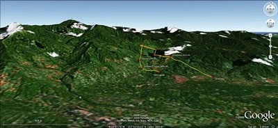
The mission’s actual ‘matching’ of collected GPS data to photographs shows that the Mineral Production Sharing Agreements (MPSA) of two mining firms [MacroAsia and Celestial Nickel Mining and Exploration Corporation (CNMEC) now operated by Ipilan Nickel Corporation (INC)] overlap with precious watersheds endowed with numerous creeks, springs and waterfalls providing potable water to the local indigenous communities and lowland farmers. More importantly, under the ECAN Guidelines of the Strategic Environmental Plan for Palawan (Republic Act 7611), such areas constitute the so called “core zones” of maximum protection where industrial extractive activities are not allowed.

At an altitude of about 500m ASL the mission reached indigenous settlements inhabited by very traditional Palawan having limited contacts with the outside. Their sustenance totally depends on the available forest resources, and it consists of a heterogeneous economy where sustainable swidden cultivation is integrated with foraging and the collection of non-timber forest products (NTFPs).


Overall, the mission moved from an elevation of a few meters ASL to an altitude of about 670m ASL, where one of the furthermost Palawan settlements is located. The mission’s GPS coordinates were obtained through the use of the JOBO GPS device being connected to the camera’s hot shoe. Positions were taken at intervals of several meters in order to reconstruct the mission’s full itinerary. The geo-tagged images were then loaded into ‘Photo GPS Editor’ and displayed on satellite Google map. All upland Palawan interviewed during the ALDAW/CBCD mission have declared that they have never been consulted about the entrance of mining companies in their traditional territories.


According to indigenous representatives, the Palawan branch of the National Commission on Indigenous Peoples (NCIP) – the government body mandated to ‘protect and promote the interest and well-being of cultural communities’ – is now siding with the mining companies. It is hoped that the ALDAW/CBCD Gantong geo-tagged report will facilitate the circulation of information, at both the national and international levels, on the threats faced by ‘irresponsible mining’ in the Philippines’ “last frontier”. An international campaign to support indigenous Palawan claims to their ancestral land has also been initiated by Survival International.

Source: The ALDAW NETWORK

The ALDAW NETWORK (Ancestral Land/Domain Watch) is an advocacy-campaign network of Indigenous Peoples jointly constituted by NATRIPAL (United Tribes of Palawan) and BANGSA PALAWAN PHILIPPINES (Indigenous Alliance for Equity and Wellbeing) on August 2009.

Friday, September 18, 2009

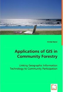
Applications of GIS in Community Forestry: Linking Geographic Information Technology to Community Participation

Planning and managing forest resources in todays ever-changing world is becoming very complex and demanding challenges to forest resource managers. Because of the multiple interests of forest users and other community interest groups, a wider range of up-to-date information is being requested in community forestry, than has been used in conventional government-based forest management in the past. Geographic Information Systems (GIS) and related technologies provide foresters and resource planners with powerful tools for planning, management and decision making. Recent trend towards community based forest management has added new dimensions and potential to use of GIS in community forestry. This book explores the potential and constraints for the application of GIS technology in community based forestry. This book will be of interest to forest managers, community development practitioners, researchers and students interested in using GIS technology in forestry and participatory GIS.

Saturday, June 20, 2009

Map symbols and coding means

Map symbols should be designed or chosen according to principles of logic and communication to serve as a graphic code for storing and retrieving data in a two or three dimensional geographic framework.

Appreciating the logic of map symbols begins with understanding the existence of three distinct categories, including point, line and polygons (areas).

Maps and 3D models include generally a combination of all three. These tree main categories can be further differentiated by variations in "hue" (color), "gray tone value", "texture" and "orientation", "shape" and "size".

Each of these variables or their combinations excel in portraying particular features and their variations.

When using color (hue) for characterizing areas, decoding is made simpler when darker means "more" and lighter means "less". Color conventions allow map symbols to exploit idealized associations of water with blue and forested areas with green. This the combination of the two, implies that dense primary forest is dark green, secondary forest green, and grassland light green, and that deep waters are dark blue and shallow waters light blue .

"Size" is more suited to for showing different in amount of count, whereas "variations in gray tone" are preferred for distinguishing differences in rate or intensity. Symbols varying in orientation are useful mostly for representing directional occurrences like winds, migration streams or other. Line symbols best portray water courses, roads, trails, boundaries and may combine different variables, including color and size (thickness). A heavier line readily suggests greater capacity or heavier traffic than a thin line implies.

Each symbol should be easily discernable from all others to clearly distinguish unlike features and provide a sense of graphic hierarchy. A poor match between the data and the visual variables may frustrate and confuse the map user.

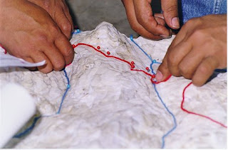
While in planimetric mapmaking the only limitation in the choice of symbols is fantasy (with logic), participatory 3-D modeling (P3DM) frequently depends on the availability of materials, particularly for point features which are generally represented by push and map pins. Lines and polygons can be easily represented by color-coded yarns and different color paints.

Standardization of symbols serves for ready unambiguous recognition of features and promotes efficiency in both map production and use, exchange of data and comparison. Maps and models sharing a common graphic vocabulary are definitely more powerful in convening the intended message and decoding simpler.

Monday, May 04, 2009

Participatory 3D Modelling in Bale, Ethiopia

MELCA Mahiber, an Ethiopian NGO member of the African Biodiversity network (ABN), facilitated the construction of a large Participatory 3D Model covering 1,575 sq. km (at a 1:12,500-scale) in Bale and West Arsi, Ethiopia.

The exercise has been done to assist local communities in planning out a more sustainable management of the area, reviving local bio-cultural diversity and supporting local environmental education.

More information on the exercise is found here.

Monday, January 05, 2009

Photo Geotagging & GPS Photo Trackers


Geotagging photographs has become an increasingly important aspect of PGIS / PPGIS practice. While the Internet already offers a wide range of online applications (Google Earth, Panoramio, Flikr, etc) where to geo-locate images, offline solutions (hardware & software) are still to be made available or even known to the many of us. I have compiled some data based on an online research dividing the available devices in three groups: Group one includes GPS-enabled cameras. Group 2 includes devices which have to be directly connected to the camera. The third group includes devices which operates separately from the camera and harvest data which have to be matched with the images taken through a three-steps process.
All result in adding latitude, longitude, altitude and time data to photographs taken with digital cameras.
More information on the research is found here.